
Unmanned aerial systems (UASs), frequently referred to as ‘drones’, have become more common and affordable and are a promising tool for collecting data on free-ranging wild animals. We used a Phantom-2 UAS equipped with a gimbal-mounted camera to estimate position, velocity and acceleration of a subject on the ground moving through a grid of GPS surveyed ground control points (GCPs) (area ∼1200m2). We validated the accuracy of the system against a dual frequency survey grade GPS system attached to the subject. When compared to GPS survey data the estimations of position, velocity and acceleration had an RMS error of 0.13m, 0.11ms−1 and 2.31ms−2 respectively. The system can be used to collect locomotion and localisation data on multiple free-ranging animals simultaneously. It does not require specialist skills to operate, is rapidly and easily deployed and easily transported to field locations. It is therefore a useful addition to the range of methods available for field data collection on free-ranging animal locomotion.
Determining position, velocity and acceleration of free-ranging animals with a low-cost unmanned aerial system

2023 JEB Outstanding Paper Prize shortlist and winner

The JEB Editors are delighted to announce the shortlisted authors for the 2023 JEB Outstanding Paper Prize. Read the winning paper - Tiny spies: mosquito antennae are sensitive sensors for eavesdropping on frog calls - by Hoover Pantoja-Sanchez and Brian Leavell from Ximena Bernal's lab at Purdue University, USA.
JEB Science Communication Workshop for ECRs
If you’re an early-career researcher interested in science communication and are attending the SEB Annual Conference in Prague this summer, come a day early and join the JEB Editors at a sci comm workshop to learn the key writing skills needed to promote your research to a broad audience beyond your peers (1 July at 14.30-17.30). Places are limited to 24 attendees, and applicants should apply through the SEB registration page by 30 April 2024.
Bridging the gap between controlled conditions and natural habitats in understanding behaviour

Novel technologies enable behavioural experiments with non-model species, in naturalistic habitats and with underexplored behaviours. In their Commentary, Scholz and colleagues discuss how to obtain a deeper understanding of the natural ecology and lifestyle of study animals.
Beluga metabolic measures could help save species
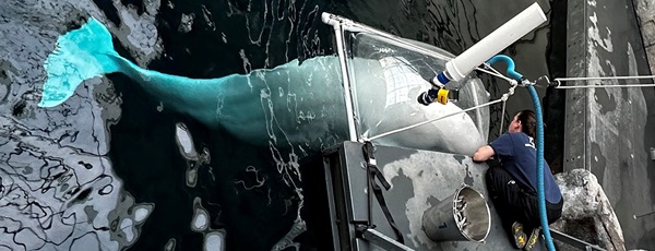
To help save animals from extinction, it’s important to understand what each species needs to survive. This led Jason John et al. to measure the metabolic rates of captive belugas to develop a ‘fish calculator’ showing that the whales need to eat ~23 salmon per day.
ECR Workshop on Positive Peer Review

Are you an ECR looking for tips on how to write concise, astute and useful manuscript reviews? If so, join the JEB Editors at a 2-hour JEB-sponsored Workshop on Positive Peer Review at the Canadian Society of Zoologists annual meeting in Moncton on 9 May 2024 at 13.00-15.00. There are 25 spaces for ECRs and selection is first come, first serve. To sign up, check the ECR Workshop box when you register for the CSZ meeting.
Social media
![]()
![]()
![]()
![]()
![]()

